1.3 mil oz @ 1,109 g/t Ag

Dolly Varden Mine (1919-1921) – 1.3 million oz at 1,109 g/t Ag (epithermal silver veins)

18.7 mil oz @ 466 g/t Ag

Torbrit Mine (1949-1959) – 18.7 million oz at 466 g/t Ag + base metal credits (volcanogenic low-sulphidation with cross cutting epithermal veins)

Dolly Varden Resource

The Dolly Varden comprises the 88 sq. km southern half of the Company’s 163 sq. km. Kitsault Valley project located in the Golden Triangle of Northwest British Columbia. It features a high-grade 100% silver resource.

It includes four known precious metal deposits: Wolf, North Star, Dolly Varden and Torbrit

The project is located adjacent to Helca Mining’s 594 sq. km. Kinskuch property and includes infrastructure such as a 25km access road to deep water and electricity at the nearby town of Kitsault.

From 2017-2021, the Dolly Varden has seen in excess of 86,000 metres of drilling with new discoveries made in a 100-year-old mining camp as a result of modern exploration technologies, data reinterpretation and drilling.

DV17-063: 22.74 m @ 433 g/t Ag

DV17-078:5.00m @ 482 g/t Ag 

DV17-063: 11.00m @ 394 g/t Ag
including: 4.00m @ 988 g/t Ag 

DV17-080: 3.39m @ 110  g/t Ag 

DV20-211: 12.75m @ 351 g/t Ag 


DV20-213: 37.50m @ 135 g/t Ag
Including 1.00m @ 906 g/t Ag  


DV20-222: 15.55m @ 204 g/t Ag
Including 6.00m @ 310 g/t Ag


DV20-275: 0.70m @ 1220 g/t Ag  


DV21-273: 17.5m @ 214 g/t Ag,
Including 1.22m @ 1,532 g/t Ag and 0.44 g/t Au

DV21-269: 303m @ 0.15 g/t Au

Dolly Varden Resource

Category Deposit Tonnes Silver (g/t Ag) Silver oz (contained)
Indicated Torbrit 2,623,000 297 25,025,000
Dolly Varden 156,000 414 2,078,000
Wolf 402,000 297 3,834,000
North Star 236,000 297 1,994,000
TOTAL 3,417,000 300 32,931,000
Inferred


Torbrit 1,185,000 278 10,588,000
Dolly Varden 86,000 272 754,000
Wolf 9,500 231 70,000
North Star 4,800 224 35,000
TOTAL 1,285,300 277 11,447,000
Zone Flotation Only Recovery (%)
Lead Concentrate Zinc Concentrate Cyanidation Float Trails Flotation + Cyanidation Whole Ore Cyanidation
Dolly Varden 65 - 54 84 86
Torbrit 64 7 59 88 87

See NI43-101 Technical report dated March 23, 2023, with effective date September 28, 2022 titled “Technical Report on the Combined Kitsault Valley Project, British Columbia, Canada” on SEDAR

  1. Mineral Resources are not Mineral Reserves as they do not have demonstrated economic viability although, as per CIM requirements, the Mineral Resources reported above have been determined to have demonstrated reasonable prospects for eventual economic extraction. 
  2. The Mineral Resources were estimated in accordance with the Canadian Institute of Mining, Metallurgy and Petroleum (CIM), CIM Standards on Mineral Resources and Reserves, Definitions (2014) and Best Practices Guidelines (2019) prepared by the CIM Standing Committee on Reserve Definitions and adopted by the CIM Council. 
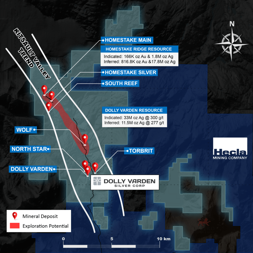
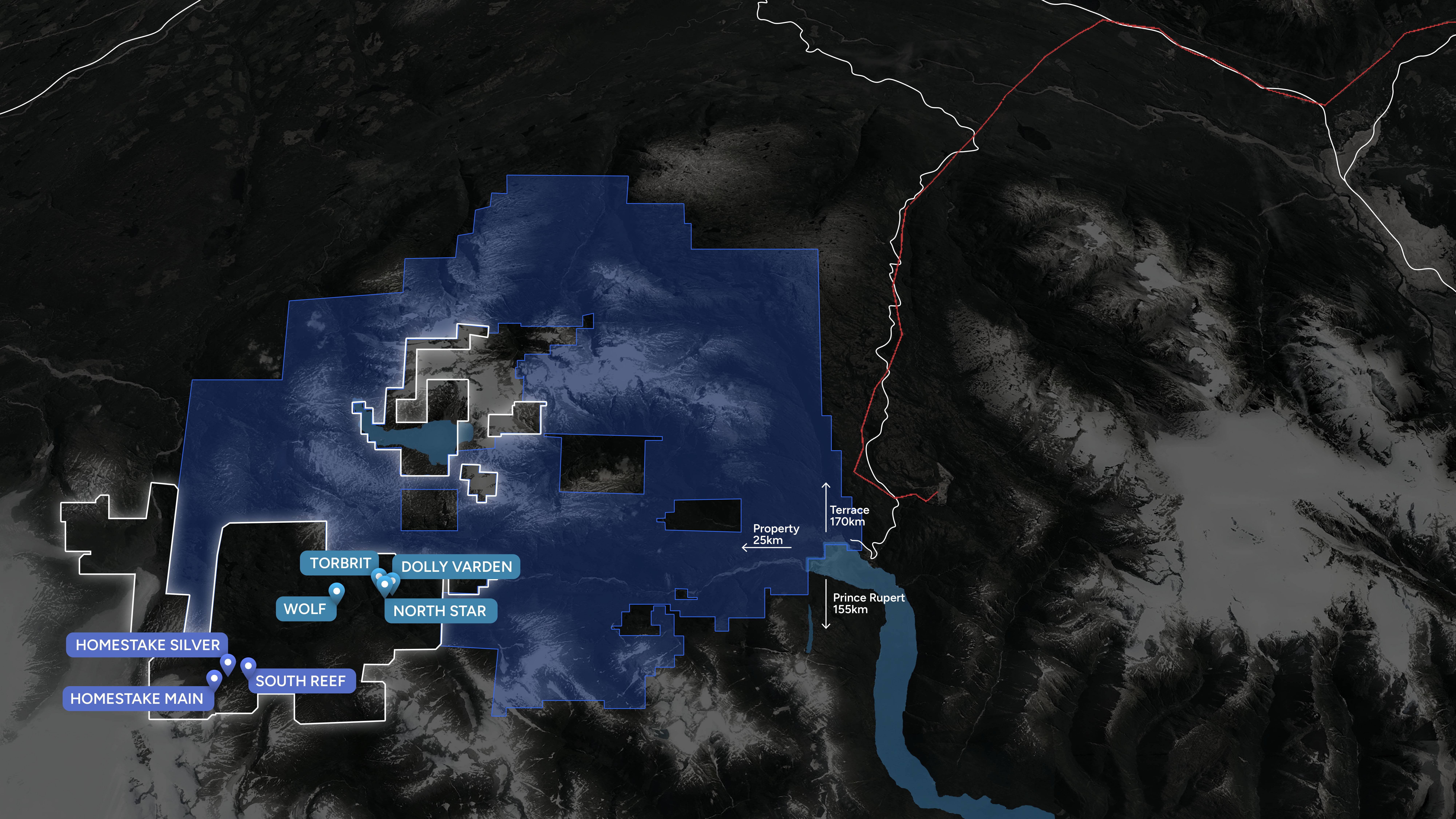
  3. The Mineral Resources for the HM (Homestake Main), HS (Homestake Silver), and SR (South Reef) Zones were originally reported in Hough et al (2022) – QPs Andrew J. Turner, P.Geol., and David Stone, P. Eng., effective date January 20, 2022.  
  4. The Mineral Resources for the TB (Torbrit), DV (Dolly Varden), NS (North Star) and WF (Wolf) Deposits were originally reported in Turner and Nicholls (2019) – QP Andrew J. Turner, P.Geol., effective date May 8, 2019. 
  5. The resources reported above are reviewed in detail within this report and are accepted as current by the Qualified Person, Mr. Andrew J. Turner, B.Sc., P.Geol., of APEX Geoscience Ltd. 
  6. The Cut-off grade for the Homestake Ridge property Mineral Resources is 2.0 g/t AuEq, which was determined using average block grade values within the estimation domains and a Au price of $1300/ tr oz, a Ag price of US$20.00/ tr oz, and a Cu price of U$2.50/lb, and Mill Recoveries of 92% for Au, 88% for Ag and 87.5% for Cu and combined mining, milling and G&A costs of approximately US$109/ton. 
  7. The Cut-off grade for the Dolly Varden property Mineral Resources is 150 g/t Ag, which was determined using a Ag price of US$20.00/ tr oz, a recovery of 90% and combined mining, milling and G&A costs of US$80/ton.  
  8. Sufficient sample density data existed to allow for estimation of block density within the estimation domains of the HM, HS and SR zones, which ranged from 2.69 t/m3 to 3.03 t/m3. 
  9. Bulk density values ranging from 2.79 t/m3 to 3.10 t/m3 were assigned to individual estimation domains based on available SG measurements for the DV, TB, NS and WF deposits. 
  10. Differences may occur in totals due to rounding. 
  11.  

Property Geology

The geology underlying the Dolly Varden property consists of volcano-sedimentary rocks belonging mostly to the lower and middle Jurassic Hazelton Group. These include intermediate volcanic and volcaniclastic rocks of the Betty Creek Formation and bimodal volcanic and sedimentary rocks of the Salmon River Formation.

The principal silver-base metal deposits of the Kitsault River valley have been interpreted as vein mineralization by early workers. Devlin (1986) reinterpreted the main deposits to be volcanic exhalative in origin. Deposits of this type are formed as sub-aqueous hot-spring type deposits on the seafloor, as products of hydrothermal solutions that have vented from sub-seafloor fracture and fault systems. Furthermore, the silver deposits of the upper Kitsault valley are mapped with important geological similarities to the Eskay Creek deposit, providing an analog for exploration on the property.

The most prominent mineralized zone on the property is an aerially extensive horizon of chemical sediment (“exhalative”) mineralization, known as the Dolly Varden-Torbrit Horizon (the “DVTH”) that extends from the Dolly Varden mine, on the west, passing through the North Star underground workings and continuing into the Torbrit mine, on the east. The DVTH exhalative body forms an almost continuous sheet, ranging in true thickness from 3 to 38 m, which extends from the Dolly Varden West zone to Moose-Lamb. Syn-depositional as well as post-dispositional faults have created a number of basins that divide the DVTH into offset blocks.

Separate from the DVTH body, the Red Point zone (on the western fringe of the upper Kitsault Valley) and the Wolf (on the eastern side of the valley) each have geological similarities to the targeted hydrothermal vein and sub-aqueous hot spring geology but are interpreted to share a position higher in the volcanic stratigraphy than the DVT horizon.

Eskay Creek Model Comparison

The Torbrit deposit which hosts the bulk of the resources on the property is similar in style to an Eskay Creek type deposit that is a striking example of a class of high-sulphidation VMS deposits, with Torbrit being a low-sulphidation example. These VMS deposits form near sub-aqueous hot-spring vents where base and precious metal-rich hydrothermal fluids exhale onto the seafloor under shallow depths of seawater.

At the Eskay Creek deposit, stratiform (bedded) layers of precious metal-rich chemical sediments and massive sulphides accumulate near vent areas and become the source for clastic sulphide debris in adjacent areas. The bedrock in the vent areas are underlain by precious metal rich feeder veins, stockwork veins and strong alteration.

A Schematic diagram, modified from Hannington, 1996, demonstrates the geological and spatial characteristics of the Precious Metal Rich VMS deposits with the key features as mapped at Dolly Varden. The DVT Exhalite which hosts the Silver deposits at Dolly Varden – North Star – Torbrit are correlated with the Barite-Silica Cap, and the Redpoint Feeder Zone correlates with the footwall stockwork alteration feed

Big Bulk & Midnight Blue

Big Bulk can be found just east of the main Kitsault Valley project area and forms part of the project. Big Bulk consists of 2,640 hectares in 7 mineral claims covering a copper-gold porphyry and skarn prospect on the southern shores of Kinskuch Lake, approximately 5 km east of the Dolly Varden Project and 23 km northeast of the village of Kitsault.

The Hazelton Group in the Kitsault area is the southern limit of a continuous belt of the the Stikine Terrane which has been shown to host large alkalic gold-copper porphyry deposits, of which the Galore Creek, Red Mountain and KSM deposits are examples. The Big Bulk copper-gold porphyry is interpreted to fall into the same age and mineralization category.

Intermittent exploration programs have taken place over several decades. Short historic drilling programs have been conducted by AngloGold Ashanti, Agnico Eagle, Teck Resources and Homestake Resources Corp. AngloGold Ashanti drilled hole AGA01 in 2009 and intercepted 0.31% Cu over 54 metres from 67 to 121 m, plus 4.0 g/t Au over 10 metres from 427 to 437 m, coincident with an IP chargeability geophysical anomaly.

As a separate mineral claim, but part of the Big Bulk Project, is the Midnight Blue claim. This location has a large copper-gold anomaly in talus fines and suggests the Big Bulk mineralization extends approximately 4 km from Kinskuch Lake southwards under ice cover to Midnight Blue. Two neighbouring companies, Hecla Mining Limited and an option by Libero Copper, hold mineral claims contiguous with Big Bulk that cover other southward extention of Big Bulk as well as other possible porphyry centers extending south towards the Kitsault Moly porphyry.

In 2017 and 2018, a joint study by the University of British Columbia and the British Columbia Geological Survey (BCGS) consisting of structural geology mapping was conducted over the Big Bulk area, with logistical support from Dolly Varden Silver. Results of this study draw parallels between the KSM system and the Big Bulk system in age and mineralization style as well as interpreting the Big Bulk/Kitsault Valley area as a sub-basin of the main Eskay Rift period.